As tensions between India and China run high due to a recent clash wherein 3 Indian soldiers and 5 Chinese soldiers got martyred, let us look at a detailed analysis of how this conflict in the Galwan Valley of Ladakh came into being-
The armies of the world’s two most populous nations are locked in a tense face-off high in the Himalayas, which has the potential to escalate as they seek to further their strategic goals. This is not the first time the two neighbors (India and China) who share a rocky relationship have faced off on the ill-defined border, where minor incursions by troops have been common.
The two countries have competing claims over their shared 3,400 kilometre (2,100 mile) border. Though both countries send out patrols that often engage in physical stand-offs, “no bullet has been fired over the border in the last four decades”. Their armies – two of the world’s largest – come face to face at many points. The poorly demarcated Line of Actual Control (LAC) separates the two sides. Rivers, lakes and snow-caps mean the line separating soldiers can shift and they often come close to confrontation.
Reason Behind the ‘Tensions’
There are several reasons – but competing strategic goals lie at the root of both the countries wanting to construct roads in their respective regions, and both sides blame each other as the road could boost Delhi’s capability to move men and material rapidly in case of a conflict.
Officials quoted by the Indian media say thousands of “Chinese troops have forced their way into the Galwan valley in Ladakh, in the disputed Kashmir region”.
The reports say that in early May, Chinese forces put up tents, dug trenches and moved heavy equipment several kilometers inside what had been regarded by India as its territory. The move came after India built a road several hundred kilometers long connecting to a high-altitude forward air base which it reactivated in 2008.
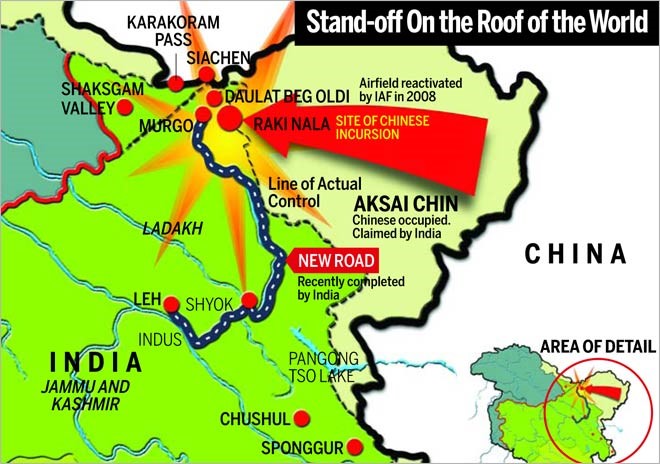
“The traditionally peaceful Galwan River has now become a hotspot because it is where the LAC is closest to the new road India has built along the Shyok River to Daulet Beg Oldi (DBO) – the most remote and vulnerable area along the LAC in Ladakh.
China takes a different view, saying it’s India which has changed facts on the ground. According to the Chinese military, India is the one which has forced its way into the Galwan valley. So, India is changing the status quo along the LAC – that has angered the Chinese,” says Dr Long Xingchun, president of the Chengdu Institute of World Affairs (CIWA).
The message from China appears clear to observers in Delhi – this is not a routine incursion.
“The situation is serious. The Chinese have come into territory which they themselves accepted as part of India. It has completely changed the status quo,” says Ajai Shukla, an Indian military expert who served as a colonel in the army.
Michael Kugelman, deputy director of the Asia programme at the Wilson Center, another think tank, says this face-off is not routine. He adds China’s “massive deployment of soldiers is a show of strength”.
Reports in the Indian media said soldiers from the two sides clashed on at least two occasions in Ladakh. Stand-offs are reported in at least three locations: the Galwan valley; Hot Springs; and Pangong lake to the south.Sometimes stand-offs involve chest-bumping, pushing and shoving, and throwing stones at each other.
The Cradle of Disputation: A Historical Context
In 1950, the Survey of India had proclaimed a map of India showcasing India’s new political divisions.
The map depicted, the border of Pakistan was shown with “Gilgit-Baltistan” as part of India and Indo-China border as “McMahon line” except in the eastern extremity where the Tirap subdivision of present Arunachal Pradesh was shown as “undefined”.
In the Central sector of what is now Uttarakhand and Himachal Pradesh and the eastern part of Jammu & Kashmir, including Aksai Chin, the boundary was depicted in this map as a colour wash and denoted as “boundary undefined.”
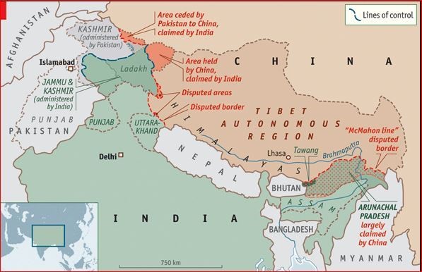
The drawing of the McMahon Line was a bit of British mischief that shaved off parts of Tibet and present-day Pakistan, and included them in British India in order to create buffer zones.
Negotiated at the Indian town of Shimla in 1914, the McMahon Line was apparently an “unscrupulous exercise in imperial cartography”, defining the border only with a thick red line on a map without reference to the usual local landmarks employed to demarcate a border.
No Chinese government has accepted the McMahon Line as the proper demarcation of the border. However, “India has embraced it”.
In 1954, as per a decision taken by Union Cabinet, the Survey of India issued a new map, one-sidedly defining the Indo-Chinese border, whereby the colour wash was replaced by a line. This is the new map which we see in Indian Official maps today (Thereafter all the old maps were withdrawn).
The Chinese claims on areas south of the “McMahon Line were based on their perceptions of traditional boundaries”, but India claimed that “the Chinese boundaries in Ladakh and Arunachal Pradesh have no written basis and no documentation of acceptance by anyone apart from China”.
After the 1962 war, the Line of Actual Control (LAC) came into being, which includes a 19-kilometer-thick border line. China kept on nibbling the Indian Territory to create new facts on ground with relation to their claimed Line of Actual Control. “They first occupy an area, then assert that it was theirs and then offer to negotiate”.
By this process, the aftermath of 1962 saw only further Chinese advance westward which led to “almost the entire Galwan River area” coming under the Chinese control but, it’s worth note that since 1956, entire Chip Chap and Galwan river valleys “were accepted by China as being Indian Territory and ironically insisted that these areas were within their claim line and occupied them following the 1962 war”.
Can It Cause a War Between India and China?
Even after the current standoff and the one before in Sikkim, a war is still not on the cards.
“We routinely see both armies crossing the LAC – it’s fairly common and such incidents are resolved at the local military level. But this time, the build-up is the largest we have ever seen,” says former Indian diplomat P Stobdan, an expert in Ladakh and India-China affairs.
“Both sides have made it a “prestige issue”. But diplomacy is all about keeping things going in difficult circumstances,” a former diplomat says.
“The stand-off is happening at some strategic areas that are important for India. If Pangong lake is taken, Ladakh can’t be defended. If the Chinese military is allowed to settle in the strategic valley of Shyok, then the Nubra valley and even Siachen can be reached.”
This triggered alarm in Delhi – and India has limited room for maneuver. It can either seek to persuade Beijing to withdraw its troops through dialogue or try to remove them by force. “Neither is an easy option”.
“China is the world’s second-largest military power.
“China has no intention to escalate tensions and I think India also doesn’t want a conflict. But the situation depends on both sides. The Indian government should not be guided by the nationalistic media comments,” says Dr Long Xingchun of the CIWA in Chengdu. “Both countries have the ability to solve the dispute through high-level talks.”
Chinese media have given hardly any coverage to the border issue, which is being interpreted as a possible signal that a route to talks will be sought. This time, too, talks are seen as the only way forward – both countries have so much to lose in a military conflict.
Both countries have the ability to solve the dispute through high-level talks. It is important to recognise that both sides have a creditable record of maintaining relative peace and stability along their disputed border. Despite the deteriorating relationship, a war is unlikely to break out.
Article by – R. Karthik
For more such articles, visit here. Also, if you have any article worthy of publishing, mail us at [email protected]
Follow our YouTube Channel- You Need To Know It


, takes action against Hong Kong")